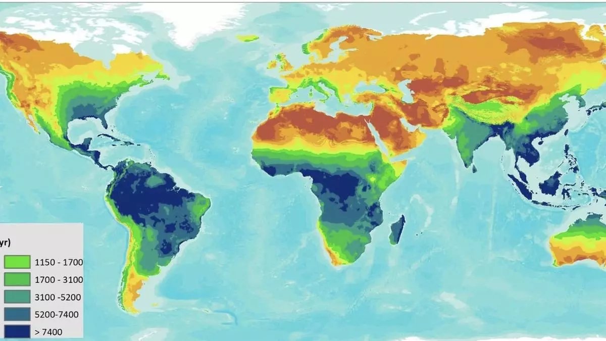
First-ever Global Rainfall Erosivity Database (GloREDa) depicts the whole of India in ‘green’ (moderate risk) category but threat from climate change could escalate it to ‘blue’ (high risk) if the government and policymakers refuse to learn from or act on the tell-tale signs already on view.
The GloREDa contains values estimated as erosivity (R) factors from 3,625 stations distributed in 63 countries worldwide, explains Nabansu Chattopadhyay, an agri-meteorologist of international renown. He co-authored a paper on global rainfall erosivity assessment that was published in Nature.
Energetic rain input
Formerly the deputy director-general and head of the agricultural meteorology division of India Meteorological Department, Chattopadhyay is currently adviser (agrometeorology) to World Bank; core member of the Service Commission on Agriculture of World Meteorological Organisation; President, International Society for Agricultural Meteorology; Secretary, South Asia Forum on Agricultural Meteorology; and senior international agro-meteorological technical consultant, Agromet Project, Bangladesh.
Nabansu Chattopadhyay
Exposure of Earth’s surface to the energetic input of rainfall is a key factor controlling water erosion. While water erosion is identified as the most serious cause of soil degradation, global patterns of rainfall erosivity remain poorly quantified and estimates have large uncertainties. This hampers implementation of effective soil degradation mitigation and restoration strategies.
Soil erosion, landslides
Heavy rainfall and extreme events are of major importance in the context of climate change. Extreme events are typically rare events of short duration, and limited observational data of sufficient temporal resolution is available to capture them. High temporal resolution rainfall measurements are useful for urban drainage models, climate change modelling, cropping patterns and crop production.
Quantifying rainfall erosivity is challenging as it requires high temporal resolution(<30 min) and hi-fidelity rainfall recordings, Chattopadhyay told businessline in the context of the calamitous landslides in Wayanad in Kerala. Landslides are a type of soil erosion that transport soil in a short time and in very large volumes. Causative factors include rainfall, soil, slope, vegetations and even humans.
Satellite tracking
Methods that estimate erosivity based on annual rainfall data are problematic and highly biased, since rainfall intensity is typically not considered. In order to include rainfall intensity in the calculation of rainfall erosivity, we need high temporal resolution rainfall data over long time periods to improve our understanding of the patterns of high-intensity rainfall events.
Ground-based observations from surface rain gauges, automatic weather stations and weather radars provide an accurate measurement of rainfall. But maintenance of rain gauges leaves a lot to be desired, Chattopadhyay said. Even otherwise, homogeneous coverage of these observations, particularly over unpopulated regions, limits their applicability. Geostationary satellites, on the other hand, provide data on a continuous basis and are viable sources of information for monitoring weather in the tropics. These could help design different adaptation and mitigation measures for reducing the impact of heavy rainfall and other unusual weather on different sectors of life, Chattopadhyay added.


